Riparian health assessment for Bear Creek, Crystal Lake
Article content
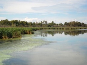
An assessment of Grande Prairie’s riparian zones is currently underway. Crews from the Alberta Riparian Habitat Management Society (Cows and Fish) will work along the edge of the stream banks and floodplains of Bear Creek, and the shores of Crystal Lake within the boundaries of City owned land, to complete a study on the heath of the terrain.
The assessment will give council and administration a better idea of proper preservation of the natural environment. The evaluation of wetland quality is the next phase outlined in the Mapping of Environmental Reserve plan, found under the 2010 Municipal Sustainability Plan.
“Riparian areas are very important because they act as a filtering system,” said Michelle Gairdner, the City’s Environmental Stewardship manager.
“A lot of people don’t understand that what goes into the storm water system – so when they’re washing their car on the driveway – goes directly into Bear Creek, so we wanted to make sure we had all the information about the riparian area. This is the second of three phases.”
Last year, the City mapped riparian zones and other natural features by conducting an inventory of the wetland complexes. However, the first phase was completed via aerial photos.
“This phase gives us information from the ground, so they’re going to be able to tell us what the health is,” Gairdner said.
The assessment will also inform the City of priority conservation areas.
“Information on environmentally sensitive areas around the creek will help them make planning and management decisions around how to maintain those areas,” said Kerri O’Shaughnessy, a riparian specialist for Cows and Fish.
“It’s going to give them a good measure of how the riparian areas are functioning in terms of providing benefits to society, like filtering water.”
As the greenery adjacent to brooks and basins, riparian corridors are critical elements in the city’s landscape, Gairdner said, playing a vital role in the healthy functioning of both surface water and the drier uplands.
A healthy zone will strengthen the stream, preventing erosion and loss of land banks, mitigating flood impacts and drought risks, ensuring sufficient water storage for drier periods, providing habitat for wildlife, even enhancing the quality of water.
However, in order to flourish, riparian areas must possess deep-rooted native vegetation.
“We’re looking at the plant species and any alterations to the natural vegetation, as well as some of the physical aspects along that shoreline, so minimal exposed soil from human activity,” O’Shaughnessy said.
According to O’Shaughnessy, assessments are completed by a team of two, who, simply, walk along the shore of water bodies or through the floodplain of watercourses. A trained eye is all it takes to detect exposed soil, loss of a diverse plant community, and risk of erosion or flood.
“To have a health study done is not necessarily a matter of need,” said O’Shaughnessy. “It’s an information tool people can use to tell them more about the property. (The City) is doing it to figure out where things are at right now.”
“You’ll see quite frequently that people who live close to a body of water manicure right down to the water’s edge instead of leaving natural vegetation in place,” Gairdner said.
“We’re going to use this information internally, but in the Environmental Stewardship department it will be used primarily for education so that people have a better understanding of what a riparian area is.”
Fieldwork will carry through until Friday. According to Gairdner, the next phase in the Mapping of Environmental Reserve plan will look at the quality of the water.
caryn.ceolin@sunmedia.ca