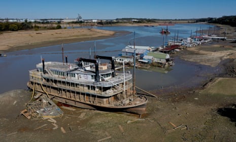
The US drought monitor declared 60% of the country to be in a designated drought zone last Thursday, with 34% in a severe or deepening drought. Although such conditions are not unusual in the US, with approximately 14% of the country having experienced severe to extreme drought every year since 1895, the extent of the current situation certainly is.
Western states and parts of the Great Plains are experiencing the most severe droughts in the country. Some central states including Minnesota and Iowa have recorded less than 25mm of rain in the past month, compared with an average of 70-100mm in September.
Such little rainfall after a warmer than average July to September has caused parts of the Mississippi River to resemble a creek. At the same time, wildfires have been raging in Washington, Oregon and New Mexico, spanning a total of more than 200,000 hectares.
The driving force behind this worsening drought is a rare “triple-dip” La Niña winter – or three consecutive La Niña winters. The weather phenomenon is known for its large-scale cooling of sea surface temperatures, resulting in colder and drier conditions in the eastern Pacific that amplify the risk of drought and wildfires in the US during winter.
There is a near 50% chance of more neutral conditions from February to April, bringing total rainfall closer to the average.
Meanwhile, temperatures in Europe are forecast to climb this week as warm air from as far south as the Sahara pushes north across western Europe via a powerful jet stream.
This airmass will bring exceptionally warm – and in some cases hot – conditions, and many places once more will experience rising temperatures, generally about 9C above average for the time of year.
Bordeaux in France is expected to climb to the high 20s Celsius, nearly 11C above the average daytime temperature in late October, and remaining in the high teens overnight.
after newsletter promotion
The summery feel will fade heading into November as temperatures tumble to the seasonal norm.
